You can read the detailed Victoria Street Issues Analysis by clicking here.
Victoria Street, Williamstown is identified as a Principal Bicycle Network Route and a bus priority route. It is a Council-managed collector road that provides north-south access from Kororoit Creek Road and Williamstown North train station to the Williamstown Beach Precinct.
Hobsons Bay is a tourist destination with many people visiting the area to attend the beach, boating, park, museum, sportsgrounds and tourist facilities. Significant inter-municipality travel occurs in Hobsons Bay, some of which are separated by long stretches of arterial road, open space and industrial land use. These long stretches of road create a physical barrier to pedestrians and cyclists in many of these locations.
The Williamstown, Altona and Werribee train lines also provide physical separation between different parts of Hobsons Bay and make inter-municipality travel challenging, particularly in a north-south direction. The physical separation between different parts of the municipality contributes to the creation of barriers between different communities and reduces the opportunities for residents of Hobsons Bay to move freely and safely about the neighbourhood and to engage with the local community. It also encourages car usage and discourages public and active transport options.
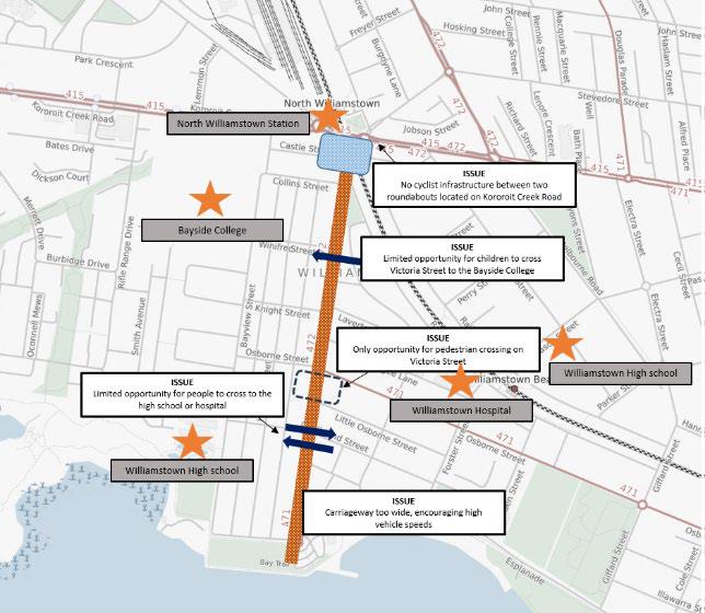
Victoria Street provides a direct north-south link for pedestrians and cyclists to access Williamstown Beach. Victoria Street also forms a barrier for vulnerable road users accessing local destinations, including children and students from the Williamstown High School Junior Campus and the Williamstown Campus of Bayside Secondary College. It can also be a barrier for pedestrians accessing the Williamstown Hospital and elderly residents to nursing homes in the area. There is only one pedestrian crossing point on Victoria Street, located at Osborne Street, providing pedestrians with a limited opportunity to cross the road.
There is limited guidance for cyclists to navigate on-road paths on Victoria with limited line marking and infrastructure to separate cyclists from vehicles. Cycling within the Victoria Street corridor is not conducive to all ages or cycling abilities. The current infrastructure directing cyclists along busy roads acts as a barrier for a less experienced cyclist or a child.
Cultural Heritage
The Victoria Street corridor is located within the Victoria Street Heritage Precinct, which comprises all land, including properties, with a frontage or side boundary to Victoria Street. Bluestone kerbing and guttering extending the length of the corridor (as well as housing facades and mature trees planted in the nature strip) are an important feature of the street and are protected under the Victorian Heritage Act 1995.
Hobsons Bay has adopted a Heritage Streets and Laneway Policy and Management Plan (2008) to provide clear policy and guidelines in managing and conserving historic public assets. This plan identifies Victoria Street and Williamstown Beach as areas of significance. The document indicates that the surviving historic fabric in the road reserves to be protected include:
• Bluestone kerb and channelling and drains, and
• Street trees (Ash species).
Concept designs need to consider the streetscape and landscape design and minimise disruption to bluestone kerbing or other heritage features wherever possible.


