28 February 2022
Thank you to everyone who submitted feedback on the two design options for the Altona Safe Boat Harbour. Click here to view the What We Heard report.
Better Boating for Altona Safe Boat Harbour
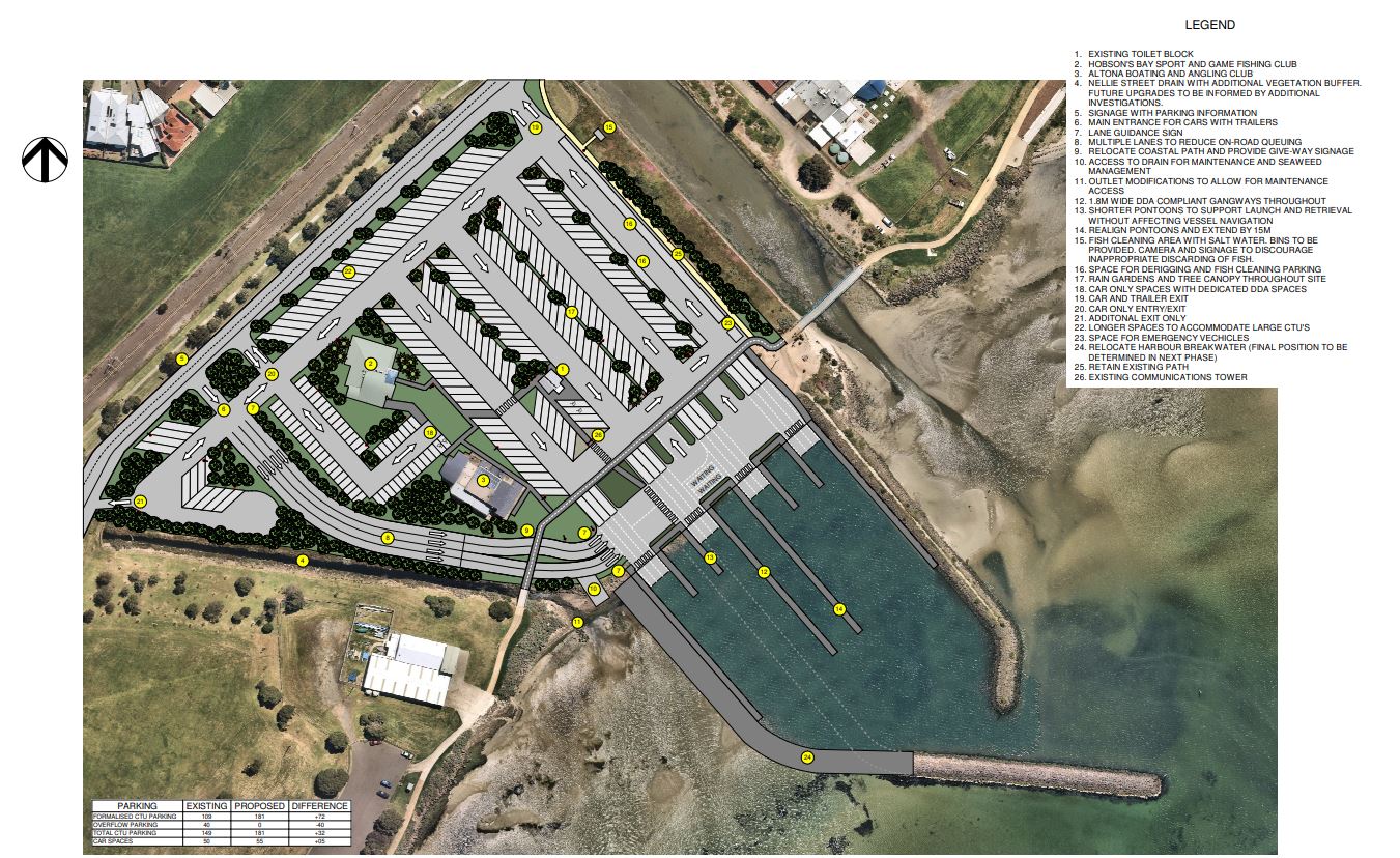
A concept plan has now been finalised following feedback from the community and key stakeholders. Better Boating Victoria will now enter a detailed design process based on the below concept plan.
For future project updates and opportunities to share your feedback please click here to visit Better Boating Victoria’s ramp upgrades webpage.
The final concept design includes realignment of the shared trail through the boat harbour, inclusion of footpaths and lawn areas connecting the two club houses and providing a shared area, separation of the car lanes at the intersection with the shared trail and a larger harbour has been created by relocating the harbour wall (dotted line indicates current location of breakwater).
Additional
features within the concept plan include
- 32 extra CTU spaces
- longer spaces for large CTU’s
- 5 extra car spaces
- extra traffic and parking signage
- rain gardens & tree canopy
- fish cleaning area equipped with saltwater
See below design concept for all features and inclusions.
The Altona Safe Boat Harbour is located on Altona Road, Seaholme. It’s an increasingly popular boat ramp facility with parking available for 105 vehicles with trailers. The facilities include public toilets and a shaded fish cleaning area. The safe boat harbour has six launching lanes and the capacity to shelter 70 to 100 boats depending upon size. The Hobsons Bay Coastal Trail leads through the precinct from WG Cresser Reserve to the favourite local dog beach. Snapper season is an exceptionally busy period for the Harbour.
Click here to find out more about Snapper season in Port Phillip Bay.
Port Phillip and Western Port represent the busiest waterways in Victoria, with four out of five Victorians visiting these ports every year, pursuing a range of water-based recreational activities. Click here to view more information about the Port Phillip and Western Port waterways.
Interpreter Service
If you are a non-English seaker, you can call Hobsons Bay interpreter service for free on:
9932 1212

Contact Us
Our friendly customer service call centre is open Monday to Friday 8.30am - 5pm to assist with all enquiries
| Phone | 1300 179 944 |
|---|---|
| customerservice@hobsonsbay.vic.gov.au | |
| Website | www.hobsonsbay.vic.gov.au |


